Four seasons on Warwick's River Avon: A view of the historic river in spring


The Warwick Boat Club ‘Old Blades’ is an informal collective of rowers who have been rowing members for more than 25 years. Over four articles, they will be raising awareness of the unique nature of the beautiful River Avon, covering each season on the river. Here is their April article covering a beautiful springtime journey on the River Avon.
Leaving the confluence of the Rivers Leam and Avon behind, just below the Portobello Bridge on the busy A452 Rugby Road, the Avon is now much wider as it meanders peacefully past the alder, willow and elderflower trees coming into bloom on the Emscote Road side, interspersed by a carpet of yellow daffodils and lesser celandine.
Advertisement
Hide AdAdvertisement
Hide AdOn the opposite left-hand bank is a majestically beautiful field, full of sheep and young lambs in spring, sloping gracefully down to the riverbanks. Dating back to the days when all around was green farmland, it is now a small green oasis surrounded by housing. The farmhouse itself nestles against the canal on higher land, a short distance from the aqueduct over the Avon.
Built as the 18th century turned into the 19th century, the canal was originally called the Warwick to Napton canal, and together with the Warwick to Birmingham canal (up the Hatton flight and through the Shrewley tunnel) these major engineering undertakings enabled a much shorter route through Warwickshire between Birmingham and London.
However, it was not until 1929 that all eight canals to London formed the Grand Union canal and it was then widened to allow 14’ beam boats, the Hatton flight alone taking over two years with over 1,000 men employed.
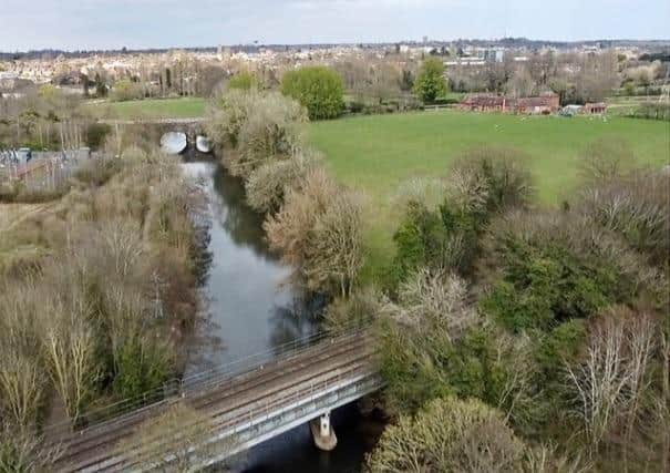
The river turns as it flows under the aqueduct and onto a straight stretch. Thick trees on the downstream left-hand side now hide the farmland while on the right hand side there are the only signs of earlier industrialisation. Concrete banks are the only visible remnants of the power station, constructed in 1920. Its original purpose was to supply DC power for the Warwick to Leamington tramway system, although this closed shortly after in 1930. Over the next couple of decades, it was first upgraded until it was producing a maximum 51MW by the late 1940s, but then downgraded to a reserve power facility before closure in the 1960s.
Advertisement
Hide AdAdvertisement
Hide AdAccess to it was not by river but off the Emscote Rd behind the old tramway depot, now Tesco, or by a branch line from the nearby main line. The branch line brought the coal to the power station and developed over the years with numerous shunting spurs, all now lost along with the power station itself, which is now the site of a substation with pylons bringing in the power for the local area instead.
Just downstream, the river passes the Environment Agency river monitoring station. Unremarkable, it is more of a small green shed than a building. It forms part of a network of similar stations that is used for monitoring the river levels, now published online.
The monitoring station is in the shadow of the next bridge. It carried the Midlands’ spur of the GWR line north from Oxford to Birmingham. Opened in 1852, the original broad-gauge tracks have long since been replaced. Despite giving the area access to London and Birmingham, it is the earlier canal that contributed more to the prosperity that Warwick enjoyed through the industrial revolution. Witness the industrial units by the canal from the Emscote Road to the Saltisford basin, most of which stand on the sites of earlier warehouses trading along the canal.
The end of the straight stretch of river arrives 200m after the railway bridge. Here there is a sharp right-hand bend after the remains of a small cut to where the boathouse of Myton Grange used to stand.
Advertisement
Hide AdAdvertisement
Hide AdShaded by a variety of trees, from statuesque poplars to plump willows, the river is now separated from the accompanying path and has a particularly ‘Wind in the Willows’ charm.
The bright flash of the occasional kingfisher darting across the river, the chorus of a chiff chaff high in the branches, the fluttering of a yellow brimstone butterfly - all evocative of the refreshing busyness of spring.
Having coped with the challenging tight bend, the river then flows round a gentle left-hand bend as it circles round the Myton Grange council playing fields and into a tighter left bend before another straight section. On the outside of this bend there are signs of a former ‘slipway’ into the river. This was probably the outflow for spent water used in the power station as a straight cut appears to go towards it on early 20th century OS maps.
The river is particularly pretty through the double bend stretch and then down to Charter Bridge. Overhanging willow trees meet in a bridge-like arch while others shelter the river from wind so that the water is typically sun-dappled, serene and tranquil. Leaving calling-card puddles in the water, we glide past the flood plain fields to the left and a steeper tree and shrub bank to our right where Victorian allotments once stood down to the river behind Pickard Street.
Advertisement
Hide AdAdvertisement
Hide AdJust beyond, we approach the Sea Scouts’ boathouse as we pass under Charter Bridge. This is the newest bridge, opened in 1996, and takes pedestrian and cycle traffic from St Nicholas Park to the schools on the Myton Road. Hidden from view to left is the fishing lake behind the reeds that also are home to the swans’ nest where eggs are being hatched.
After the tighter left-hand bend from Charter Bridge, the river turns gently to the right, narrowing through a slot between the abandoned Warwick Sailing Club grounds on the left and a tree-lined section of St Nicholas Park where the Victorian public lido used to stand by the old river. Subsequently, St Nicholas Park - formally a flood plain meadow - was elevated in the 1920s by the addition of soil covered town waste prior to being developed in its current form along with the town boathouse.
Next up, we enter the ‘regatta-straight’. Not really a straight, it starts with a flowing right-hand bend to the upstream finish point of the regattas with a slight left-hand bend at the ferry crossing in the Myton Fields and then a final more distinct right-hand bend just after the imposing sandstone of the listed Castle Bridge, opened in 1793 to road traffic.
The final stretch of the river, after the grandeur of the Castle Bridge, passes by the Boat Club and houses at the end of Mill Street. The new boathouse, immediately after the bridge, houses today’s rowers but at the other end of the club grounds you can still see a small cut, which used to service the old boathouse (see picture in this article) on the site of the club’s car park. Opposite the club, the delightful houses of Bridge End, with their picturesque gardens, run down to the river. Now considered very affluent, this hamlet used to house some of the poorer communities in Warwick, outside of the town walls and over the medieval bridge that used to be the main access into Warwick, and which was closely guarded by the castle. The medieval bridge is now sadly a ruin.
Advertisement
Hide AdAdvertisement
Hide AdFrom this delightful stretch of river, the development of Warwick is clear to see from canal, railway, foot, and road bridges that progressively replaced the original medieval cart access.
Just a few metres beyond the ruined bridge, the river flows over the castle weir with the mill tucked under the shadow of the castle. We can go no further down the Avon but the river continues with amazing variety, including the shallow wide rock flats at Barford and the heavily reeded banks snaking through the grandeur of Charlecote Park, before becoming a very narrow overgrown fast-flowing stream near Tiddington and subsequently widening out again on its way into a substantial river flowing to Stratford upon Avon and onwards to the River Severn at Tewksbury.